

Signals from at least four satellites in orbit reach a handheld or vehicle-mounted receiver to determine a precise location through a process where gps tracking devices work by timing the travel of radio waves. The device calculates the distance to each satellite by measuring the time it takes for a signal to arrive, which allows it to pinpoint a coordinate on Earth. It is like listening for echoes in a large room to find your position, but instead of sound, the device uses electromagnetic waves moving at the speed of light.
Parts Inside How GPS Tracking Devices Work
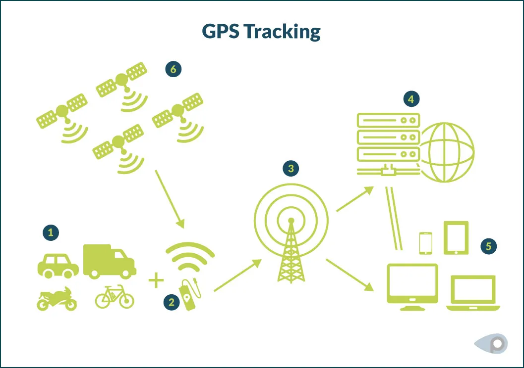
These systems rely on a combination of space-based hardware and ground-based processing to function. You can identify if a component is failing by checking the indicator lights or the status menu on the device software.
| Part or input | What it does | What you notice when it goes wrong |
|---|---|---|
| Satellite constellation | Sends timing signals | No signal reception |
| Antenna | Captures radio waves | Weak or intermittent connection |
| Receiver chip | Processes orbital data | Slow startup or drift |
| Memory storage | Saves movement history | Missing log data |
| Cellular modem | Sends location to server | Real-time updates stop |
When the antenna is blocked by heavy metal or dense concrete, the device can’t see the sky, which stops it from getting a fix. If your device shows a “cold start” status for more than ten minutes, it’s failing to lock onto the minimum four satellites required for a precise coordinate.
Most users mistakenly assume a weak signal is a hardware defect. In reality, placing the device near an active Wi-Fi router or high-voltage power line often causes enough electromagnetic interference to scramble the receiver. If you see erratic jumping on your map, move the unit to an open area at least twenty feet away from electronic noise.
If the unit displays a “data lag” error, have a technician check the battery voltage first. A drop below 3.3 volts often forces the modem to disable its radio to preserve core system functions. If the voltage is stable but the logs remain empty, the internal memory buffer is likely corrupted.
You must perform a factory reset to clear the cache, though this will permanently erase all stored movement history. Always verify the firmware version before initiating a reset, as older software versions may require a manual patch to recognize the storage partition again.
Steps for calculating position
The process of finding a location happens in a continuous loop while the device is powered on. Each cycle lasts only a fraction of a second, allowing for near-instant updates.
-
The device wakes up and searches for signals from satellites currently visible above the horizon. If you’re in a deep urban canyon or under dense tree cover, the device may struggle to see more than three satellites. In these cases, the position will fail to lock or will drift significantly.
-
It locks onto the strongest signal from at least four satellites to establish a 3D position. Three satellites provide a 2D coordinate, but the fourth is mandatory to calibrate the internal clock against the precise atomic time of the satellite constellation.
-
The internal clock compares the arrival time of the signals against the known transmission time. Because these signals travel at the speed of light, a discrepancy of just one microsecond introduces a 300-meter error in the calculated distance to a satellite.
-
It performs a trilateration calculation to turn those time differences into latitude, longitude, and altitude. If you’re at sea level, the device often assumes a standard geoid model to refine the altitude calculation.
-
The processor updates the internal map coordinate or log file with this new timestamped data. Most users make the mistake of assuming the first coordinate is the most accurate. Always wait for the horizontal accuracy estimate to drop below ten meters before relying on the data.
-
If a cellular connection is available, the device transmits these coordinates to a remote server. If you lack a cellular signal, the device stores the data locally until a connection is restored, which may cause a sudden, large jump in your displayed path history.
Connection between signals and errors

The accuracy of your position depends entirely on the clarity of the connection between the satellites and the receiver. When a device struggles to provide a location, it’s usually because the signal path is interrupted by environmental factors. Urban canyons created by tall buildings reflect signals off glass and steel before they reach the antenna. This confuses the receiver during its calculation process.
This phenomenon is known as multipath interference. It causes your location to jump around on a map even when you’re standing perfectly still. The reflected signal arrives later than the direct line-of-sight transmission. Your device interprets this time delay as extra distance traveled through space.
If your device shows you’re in the wrong street, the signal is likely bouncing off nearby structures. The receiver thinks the signal traveled further than it actually did because of the detour. This leads to a calculation error of several meters that no software update can fully correct. You can distinguish multipath from simple signal loss by watching the behavior of the position dot.
A weak signal makes the dot fade or stop updating entirely. Multipath keeps the dot active but places it confidently in the wrong spot. Open sky provides the best results because signals arrive directly without interference. Dense forest canopy or deep valleys weaken signal strength instead. This degradation leads to a loss of precision or a complete failure to lock on.
The Global Positioning System standard defines how these signals must be handled to maintain accuracy. When a device lacks a clear view of the sky, the processor can’t verify timing data from enough satellites. Four distinct satellite connections are required for a valid three-dimensional fix. Anything less forces the unit to rely on older data or less accurate methods.
Cellular tower triangulation often fills this gap but is far less precise than satellite positioning. Tower-based fixes may place you within hundreds of meters rather than single digits. If you notice your device has a delay, check if you’re under a metal roof. Metal acts as a Faraday cage that blocks radio frequencies almost completely.
Large electronic interference sources also degrade performance by raising the noise floor. High-voltage transformers and certain radar installations emit frequencies that overlap with navigation bands. These external factors dictate the limits of the hardware regardless of chip quality. Moving just ten feet away from a reflective wall can sometimes restore direct signal reception.
Wet foliage attenuates signals much more severely than dry leaves. Rain or dew on tree branches introduces water content that absorbs L-band frequencies. A path that worked yesterday may fail today after a storm passes through. Understanding this distinction prevents unnecessary troubleshooting of perfectly functional equipment. Glass windows with metallic coatings block signals while clear glass does not.
Modern receivers use algorithms to identify and discard bounced signals. They compare expected signal strength against actual measurements to flag suspicious data. This mitigation helps but can’t eliminate physics. The environment ultimately sets the boundary for positional accuracy. No amount of processing overcomes a fundamentally corrupted signal path. Hardware sensitivity only matters when usable radio signals actually reach the antenna.
Controls and design limits
You can manage how the device behaves, but you can’t change the fundamental physics of satellite communication. Understanding these limits prevents frustration when the technology fails to meet impossible expectations.
Things you control
- Update the firmware to ensure the receiver processes timing data correctly.
- Clear any obstructions from the antenna’s line of sight to the sky.
- Adjust the reporting interval to save battery or increase data detail.
- Toggle between satellite networks if your device supports multi-constellation tracking.
Things fixed by design
- The speed of light, which limits how fast a signal can travel.
- The physical size of the antenna, which dictates signal sensitivity.
- The number of satellites in orbit, which you can’t influence or change.
Professional surveying equipment requires specialized software and base stations to reach millimeter accuracy, which is beyond the reach of standard consumer devices. If your application requires legal-grade precision, you should consult with a certified land surveyor.
Habits for better performance
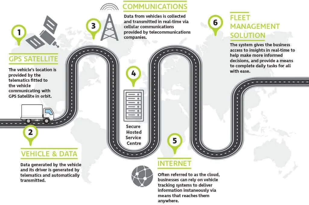
Using these devices effectively requires acknowledging the environment where you operate. Since the system relies on line-of-sight communication with satellites, your location and orientation matter significantly.
Always mount the device with the antenna facing the sky. If the antenna is covered by metal or located in a basement, it will struggle to maintain a lock. Even dense tree canopy can reduce signal strength enough to cause intermittent dropouts during critical tracking windows.
When you first turn on the device, give it 1 to 3 minutes to perform a cold start. This allows the receiver to download the latest orbital data from the satellites, which makes subsequent locks much faster. Rushing this step forces the unit to guess satellite positions, extending acquisition time unpredictably.
If you move from indoors to outdoors, allow the device to sit stationary for a moment so it can refresh its position from the new signal environment. Walking immediately after power-on introduces Doppler shift errors that confuse the initial fix calculation.
Check your battery level regularly, as high-frequency reporting intervals drain power much faster than standard tracking. A one-minute interval consumes roughly ten times more energy than a ten-minute setting. Match your reporting frequency to your actual need rather than leaving it at maximum by default.
If you’re in a location with poor cellular coverage, many devices will cache data locally. Ensure the internal memory has enough capacity for your planned trip, or the device will overwrite the oldest data to make room for the new. Calculate storage needs before departure based on expected outage duration and chosen interval.
Keep the device away from strong magnetic fields or other radio transmitters, as these can introduce noise into the sensitive receiver circuitry. Mounting near a vehicle’s alternator or two-way radio often causes unexplained position drift that mimics hardware failure.
Test your setup in known good conditions before relying on it in remote areas. Verify that reported positions match visible landmarks within acceptable tolerance. Discovering a mounting error at home costs minutes; discovering it during an emergency costs safety.
Temperature extremes also affect performance beyond what specifications suggest. Cold reduces battery capacity temporarily, while heat accelerates permanent degradation. Store and charge the device at room temperature whenever possible to preserve both runtime and longevity.
Firmware updates sometimes improve acquisition algorithms or fix memory management bugs. Check for updates before extended trips, but never update in the field unless absolutely necessary. Failed updates during deployment can brick a unit when replacement is impossible.
Conclusion
Whether you’re planning a cross-country road trip or just trying to keep track of your keys, this technology makes navigating the world much easier. It’s a reliable tool that’s always working in the background. You should check your smartphone’s map settings today to see how accurately it’s tracking your current location.
Related guides